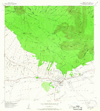
1956 Map of Kamuela
USGS Topo · Published 1967About this map
Waimea sits at the high-elevation transition between the lush windward slopes of the Kohala Mountains and the arid leeward plains of South Kohala. In the mid-1950s, this area was defined by the organized agricultural blocks of the Waimea Homesteads and Puukapu Homesteads, reflecting the local legacy of ranching and territorial land distribution. The map shows the Parker Ranch Racetrack and the Waimea Airport (Abandoned) south of the main settlement, alongside early infrastructure like the Waihoalana Ditch and several diversion dams.
Find a feature on this map
106 named features on this map. Tap any name to fly to it.
Don’t see what you’re looking for? This feature index may not catch every label — zoom into the map to look around manually.
Map Details
Editions of this 1956 Kamuela Map
3 editions found
Other maps of this area

1913 · Kohala
USGS Topo · 1:62,500

1916 · Kohala
USGS Topo · 1:62,500

1916 · Waipio
USGS Topo · 1:62,500

1928 · Puako
USGS Topo · 1:62,500

1954 · Hawaii North
USGS Topo · 1:250,000

1956 · Puu Hinai
USGS Topo · 1:24,000

1956 · Kamuela
USGS Topo · 1:24,000

1956 · Nohonaohae
USGS Topo · 1:24,000

1956 · Makahalau
USGS Topo · 1:24,000

1956 · Kawaihae
USGS Topo · 1:24,000