
1972 Map of Kanawha SE
USGS Topo · Published 1975About this map
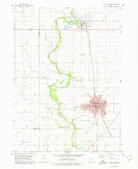
The agricultural landscape of Norway and Liberty townships is defined by the winding paths of Otter Creek and Eagle Creek as they drain the central Iowa prairie. In the early 1970s, this region remained a patchwork of section-line roads and family farms, punctuated by quiet community landmarks. Small country congregations are represented by Wright Ch in the north and St Johns Ch further east, reflecting the enduring social fabric of the rural township system. A local Community Center and the Township Cemetery serve as central gathering points for the surrounding sections. While primarily focused on cultivation, the presence of a Gravel Pit indicates local industrial activity. The map also captures the path of Little Eagle Creek in the south, illustrating the natural drainage patterns that shaped the early development of Lake and Boone townships.
Find a feature on this map
12 named features on this map. Tap any name to fly to it.
Don’t see what you’re looking for? This feature index may not catch every label — zoom into the map to look around manually.
Map Details
Editions of this 1972 Kanawha SE Map
This is the sole edition of this map. No revisions or reprints were ever made.
Other maps of this area

1954 · Waterloo
USGS Topo · 1:250,000

1955 · Waterloo
USGS Topo · 1:250,000

1972 · Cornelia
USGS Topo · 1:24,000

1972 · Corwith
USGS Topo · 1:24,000

1972 · Kanawha
USGS Topo · 1:24,000

1972 · Olaf
USGS Topo · 1:24,000

1972 · Renwick
USGS Topo · 1:24,000

1978 · Holmes
USGS Topo · 1:24,000

1978 · Clarion
USGS Topo · 1:24,000
1978 · Eagle Grove
USGS Topo · 1:24,000