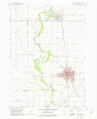
1978 Map of Eagle Grove
USGS Topo · Published 1979About this map
The Boone River meanders through the heart of this North Central Iowa landscape, defining the boundaries between Lake, Eagle Grove, and Liberty townships. The map documents the mid-century infrastructure of Eagle Grove, where the grid of Broadway and 4th St S serves as the hub for local education and industry. Notable sites include the Iowa Central Community Coll, Sacred Heart Church, and the Eagle Grove Municipal Airport.
Find a feature on this map
58 named features on this map. Tap any name to fly to it.
Don’t see what you’re looking for? This feature index may not catch every label — zoom into the map to look around manually.
Map Details
Editions of this 1978 Eagle Grove Map
This is the sole edition of this map. No revisions or reprints were ever made.
Other maps of this area

1923 · Fort Dodge
USGS Topo · 1:62,500

1954 · Waterloo
USGS Topo · 1:250,000

1954 · Fort Dodge
USGS Topo · 1:250,000

1955 · Waterloo
USGS Topo · 1:250,000

1957 · Fort Dodge
USGS Topo · 1:250,000

1958 · Fort Dodge
USGS Topo · 1:250,000

1972 · Kanawha SE
USGS Topo · 1:24,000

1972 · Renwick
USGS Topo · 1:24,000
1972 · Hardy
USGS Topo · 1:24,000

1978 · Holmes
USGS Topo · 1:24,000