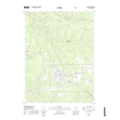
2019 Map of Kane
USGS Topo · Published 2019About this map
The borough of Kane serves as the central hub of this survey, surrounded by the dense timberlands of the Allegheny National Forest. The map detail reveals a community deeply integrated with its geography, from the residential grids of East Kane and Greendale to the outlying settlements of Wetmore and Sergeant. Genealogists will find significant value in the documentation of several local burial grounds, including Forest Lawn Cem, Mount Tabor Cem, and the Saint Callistus Cem. The terrain is defined by a complex network of waterways such as the South Branch Kinzua Creek and Wilson Run, which have historically dictated the placement of roads and rail corridors. Modern recreational use is prominent throughout the forest, evidenced by the extensive Allegheny Snowmobile Loop and multiple snowmobile connectors that weave through the high ridges of Clarion Summit and Rocky Ridge.
Find a feature on this map
78 named features on this map. Tap any name to fly to it.
Don’t see what you’re looking for? This feature index may not catch every label — zoom into the map to look around manually.
Map Details
Editions of this 2019 Kane Map
This is the sole edition of this map. No revisions or reprints were ever made.
Other maps of this area

1924 · Bradford
USGS Topo · 1:62,500

1926 · Bradford
USGS Topo · 1:62,500

1934 · Kane
USGS Topo · 1:48,000

1935 · Mt. Jewett
USGS Topo · 1:48,000

1936 · Kinzua
USGS Topo · 1:48,000

1939 · Kane
USGS Topo · 1:62,500

1940 · Mt. Jewett
USGS Topo · 1:62,500

1941 · Kinzua
USGS Topo · 1:62,500

1941 · Bradford
USGS Topo · 1:62,500

1944 · Bradford
USGS Topo · 1:62,500
Featured Places
- Kane, PA
- Sergeant, Wetmore Township
- Jo Jo, Wetmore Township
- East Kane, Wetmore Township
- Greendale, Wetmore Township