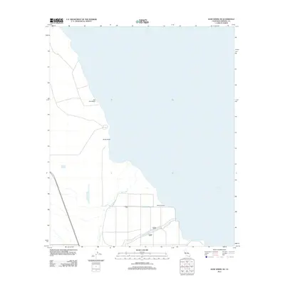
2012 Map of Kane Spring NE
USGS Topo · Published 2012About this map
Salton Sea dominates the eastern half of this landscape, its fluctuating shoreline defining the local geography near View Beach and Sandy Beach. This 2012 topographic survey captures the structured water management systems of the Imperial Valley, where irrigation and drainage infrastructure are essential to the desert environment. Notable features include the Trifolium Drain and several lateral channels, such as Lateral Nine, Lateral Eight, and Lateral Seven. These engineered waterways intersect with the natural drainage of the San Felipe Cr and the wider San Felipe Wash, illustrating the intersection of natural hydrology and human-controlled agricultural water systems near the basin floor. The map provides a clear record of the access roads and shore-bound settlements as they existed a decade ago.
Find a feature on this map
9 named features on this map. Tap any name to fly to it.
Don’t see what you’re looking for? This feature index may not catch every label — zoom into the map to look around manually.
Map Details
Editions of this 2012 Kane Spring NE Map
This is the sole edition of this map. No revisions or reprints were ever made.
Other maps of this area

1940 · Kane Spring
USGS Topo · 1:62,500

1940 · Frink
USGS Topo · 1:62,500

1940 · Durmid
USGS Topo · 1:62,500

1944 · Durmid
USGS Topo · 1:62,500

1944 · Kane Spring
USGS Topo · 1:62,500

1944 · Calipatria
USGS Topo · 1:62,500

1944 · Frink
USGS Topo · 1:62,500

1954 · Salton Sea
USGS Topo · 1:250,000

1955 · Salton Sea
USGS Topo · 1:250,000
1956 · Durmid SE
USGS Topo · 1:24,000