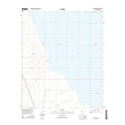
2015 Map of Kane Spring NE
USGS Topo · Published 2015About this map
Salton Sea dominates the eastern portion of this desert landscape, its modern shoreline meeting the edge of the Imperial Valley. The western margin reveals the transition from low-lying desert floor to the rising topography of the surrounding ranges, bisected by the Salton Sea Rd. Small coastal settlements like Sea View Beach and Sandy Beach suggest a pocket of human activity along the water's edge, even as natural drainage features like San Felipe Creek and San Felipe Wash indicate the seasonal hydraulic patterns of the basin. The southern section of the map illustrates the organized agricultural infrastructure essential to this region, marked by the Trifolium Drain and Lateral Nine, which channel water into the arid valley floor. This confluence of recreation, irrigation, and harsh desert terrain highlights the complex management of California's inland sinks.
Find a feature on this map
13 named features on this map. Tap any name to fly to it.
Don’t see what you’re looking for? This feature index may not catch every label — zoom into the map to look around manually.
Map Details
Editions of this 2015 Kane Spring NE Map
This is the sole edition of this map. No revisions or reprints were ever made.
Other maps of this area

1940 · Kane Spring
USGS Topo · 1:62,500

1940 · Frink
USGS Topo · 1:62,500

1940 · Durmid
USGS Topo · 1:62,500

1944 · Durmid
USGS Topo · 1:62,500

1944 · Kane Spring
USGS Topo · 1:62,500

1944 · Calipatria
USGS Topo · 1:62,500

1944 · Frink
USGS Topo · 1:62,500

1954 · Salton Sea
USGS Topo · 1:250,000

1955 · Salton Sea
USGS Topo · 1:250,000
1956 · Durmid SE
USGS Topo · 1:24,000