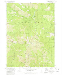
1980 Map of Kangaroo Mtn.
USGS Topo · Published 1980About this map
The Pacific Crest National Scenic Trail winds through the high-elevation divide where the Rogue River National Forest meets the Klamath National Forest. This 1980 survey reveals a remote backcountry landscape defined by steep drainages and isolated alpine basins. Small glacial lakes like Hello Lake, Echo Lake, and Lily Pad Lake dot the terrain beneath peaks such as Rattlesnake Mtn and Kangaroo Mtn.
Find a feature on this map
59 named features on this map. Tap any name to fly to it.
Don’t see what you’re looking for? This feature index may not catch every label — zoom into the map to look around manually.
Map Details
Editions of this 1980 Kangaroo Mtn. Map
2 editions found
Other maps of this area

1908 · Grants Pass
USGS Topo · 1:125,000

1914 · Seiad
USGS Topo · 1:125,000

1922 · Seiad
USGS Topo · 1:125,000

1948 · Weed
USGS Topo · 1:250,000

1950 · Weed
USGS Topo · 1:250,000

1954 · Oregon Caves
USGS Topo · 1:62,500

1954 · Ruch
USGS Topo · 1:62,500

1955 · Seiad Valley
USGS Topo · 1:62,500

1955 · Medford
USGS Topo · 1:250,000

1956 · Happy Camp
USGS Topo · 1:62,500