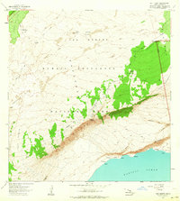
1963 Map of Kau Desert
USGS Topo · Published 1964About this map
The volcanic landscape of Kapapala meets the sea in this detailed study of the Kau Desert, where centuries of activity are etched into the earth. The map records the Keamoku Lava Flow and the 1920 Lava Flow, illustrating the shifting geology within Hawaii Volcanoes National Park. The steep drop of Hilina Pali dominates the terrain, creating a natural barrier between the upland volcanic plateaus and the rugged coastline. Isolated green islands of vegetation known as kipukas, such as Kipuka Nene and Kipuka Ahiu, dot the otherwise desolate desert floor. These areas provided rare refuge for travelers and local life, evidenced by the Kipuka Nene Picnic Area and the Rain Shed. Along the coast, small landmarks like Kaaha and Kakiwai mark the edge of the Pacific Ocean, accessible by historical routes like the Puna Trail.
Find a feature on this map
45 named features on this map. Tap any name to fly to it.
Don’t see what you’re looking for? This feature index may not catch every label — zoom into the map to look around manually.
Map Details
Editions of this 1963 Kau Desert Map
2 editions found
Other maps of this area

1921 · Kilauea
USGS Topo · 1:62,500

1922 · Puna
USGS Topo · 1:62,500

1923 · Pahala
USGS Topo · 1:62,500

1924 · Kilauea
USGS Topo · 1:62,500

1924 · Puna
USGS Topo · 1:62,500

1954 · Hawaii South
USGS Topo · 1:250,000

1959 · Hawaii South
USGS Topo · 1:250,000

1961 · Hawaii South
USGS Topo · 1:250,000

1962 · Hawaii South
USGS Topo · 1:250,000
1963 · Volcano
USGS Topo · 1:24,000