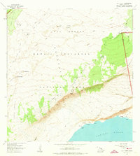
1963 Map of Kau Desert
USGS Topo · Published 1973About this map
Hawaii Volcanoes National Park dominates this coastal survey, where the terrestrial power of the Kau Desert meets the Pacific Ocean. The landscape is defined by its volcanic activity, notably the Lava Flow of 1920 and the jagged Kamakaia Hills. Researchers will find pockets of vegetation known as kipukas, such as Kipuka Nene and Kipuka Pepeiau, which provide ecological contrast to the surrounding lava fields and pit craters. Along the dramatic southern coastline, the land drops precipitously at Hilina Pali and Makahanu Pali. Historical landmarks like the Footprints and the Pepeiau Shelter reflect the intersection of geological history and human traversal through this volatile region. The presence of a Rain Shed and scattered waterholes like Kakliwai underscores the arid, challenging environment of the desert landscape during the mid-twentieth century.
Find a feature on this map
40 named features on this map. Tap any name to fly to it.
Don’t see what you’re looking for? This feature index may not catch every label — zoom into the map to look around manually.
Map Details
Editions of this 1963 Kau Desert Map
2 editions found
Other maps of this area

1921 · Kilauea
USGS Topo · 1:62,500

1922 · Puna
USGS Topo · 1:62,500

1923 · Pahala
USGS Topo · 1:62,500

1924 · Kilauea
USGS Topo · 1:62,500

1924 · Puna
USGS Topo · 1:62,500

1954 · Hawaii South
USGS Topo · 1:250,000

1959 · Hawaii South
USGS Topo · 1:250,000

1961 · Hawaii South
USGS Topo · 1:250,000

1962 · Hawaii South
USGS Topo · 1:250,000
1963 · Volcano
USGS Topo · 1:24,000