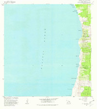
1982 Map of Kauluoa Point
USGS Topo · Published 1982About this map
The coastal shelf of South Kona meets the Pacific Ocean in this detailed 1982 survey of the Kauluoa Point coastline. The landscape is defined by the remnants of the volcanic activity that shaped the island, notably featuring the Honokua Lava Flow of 1950 and a similar flow at Kaapuna. Settlement is concentrated in upland areas away from the immediate shore, where the Olelomoana Homesteads and Haukalua 2 Homesteads reflect local land divisions. Education and community infrastructure are visible through the Alae Sch and several scattered Rain Shed locations, which were essential for water catchment in this environment. The northern reaches include Kalahiki Beach and Lapaiwai Bay, while the southern boundary transitions into the protected South Kona Forest Reserve. This map illustrates the intersection of mid-century geological events with the long-standing agricultural and residential patterns of the Kona district.
Find a feature on this map
47 named features on this map. Tap any name to fly to it.
Don’t see what you’re looking for? This feature index may not catch every label — zoom into the map to look around manually.
Map Details
Editions of this 1982 Kauluoa Point Map
This is the sole edition of this map. No revisions or reprints were ever made.
Other maps of this area

1928 · Hoopuloa
USGS Topo · 1:62,500

1954 · Hawaii South
USGS Topo · 1:250,000

1959 · Hawaii South
USGS Topo · 1:250,000

1959 · Honaunau
USGS Topo · 1:24,000
1960 · Kaunene
USGS Topo · 1:24,000

1961 · Hawaii South
USGS Topo · 1:250,000

1962 · Hawaii South
USGS Topo · 1:250,000

1962 · Milolii
USGS Topo · 1:24,000

1962 · Papa
USGS Topo · 1:24,000
1962 · Kauluoa Point
USGS Topo · 1:24,000