
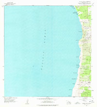
1962 Map of Kauluoa Point
USGS Topo · Published 1964About this map
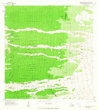
The Honokua Lava Flow of 1950 scars the landscape of South Kona, reaching from the inland slopes down to the Pacific Ocean shoreline. This coastal survey illustrates the immediate aftermath of mid-century volcanic activity on the Island of Hawaii, showing how recent flows intersected with established indefinite boundaries and early land grants. Along the rugged coast, small settlements and agricultural plots are identified as Kaukalua 2 Homesteads, Alae 1-2 Homesteads, and Olelomoana Homesteads. The reliance on collected water in this porous volcanic terrain is evidenced by several Rain Shed, often the only structures located along the network of Jeep Trails. To the south, the Kipahoehoe Forest Reserve covers the steeper grades, while coastal landmarks like Kauluoa Pt and Kalahiki Beach define the interaction between the lava and the sea.
Find a feature on this map
46 named features on this map. Tap any name to fly to it.
Don’t see what you’re looking for? This feature index may not catch every label — zoom into the map to look around manually.
Map Details
Editions of this 1962 Kauluoa Point Map
2 editions found
Other maps of this area

1928 · Hoopuloa
USGS Topo · 1:62,500

1954 · Hawaii South
USGS Topo · 1:250,000

1959 · Hawaii South
USGS Topo · 1:250,000
1959 · Honaunau
USGS Topo · 1:24,000

1960 · Kaunene
USGS Topo · 1:24,000

1961 · Hawaii South
USGS Topo · 1:250,000

1962 · Hawaii South
USGS Topo · 1:250,000
1962 · Milolii
USGS Topo · 1:24,000
1962 · Papa
USGS Topo · 1:24,000
1963 · Puu Pohakuloa
USGS Topo · 1:24,000