
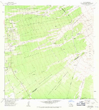
1962 Map of Papa
USGS Topo · Published 1964About this map
Recent volcanic activity defines the landscape of the South Kona and Kau districts in the early 1960s, where successive eruptions have left massive scars across the terrain. The Hoopuloa Lava Flow of 1926 and the Alika Lava Flow of 1919 cut broad swaths through the South Kona Forest Reserve, illustrating the dynamic nature of Hawaii's geology. Between these flows, evidence of localized industry and settlement remains, including the Koa Mill and Ohia Mill, alongside residential clusters at the Papa Homesteads and Alika Homesteads.
Find a feature on this map
47 named features on this map. Tap any name to fly to it.
Don’t see what you’re looking for? This feature index may not catch every label — zoom into the map to look around manually.
Map Details
Editions of this 1962 Papa Map
2 editions found
Other maps of this area

1924 · Honuapo
USGS Topo · 1:62,500

1928 · Mauna Loa
USGS Topo · 1:62,500

1928 · Hoopuloa
USGS Topo · 1:62,500

1954 · Hawaii South
USGS Topo · 1:250,000

1959 · Hawaii South
USGS Topo · 1:250,000

1961 · Hawaii South
USGS Topo · 1:250,000

1962 · Hawaii South
USGS Topo · 1:250,000

1962 · Milolii
USGS Topo · 1:24,000

1962 · Kahuku Ranch
USGS Topo · 1:24,000
1962 · Manuka Bay
USGS Topo · 1:24,000