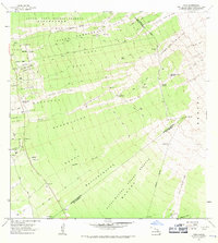
1962 Map of Papa
USGS Topo · Published 1971About this map
Frozen lava flows dominate this South Kona landscape, recording the volcanic activity that reshaped the island throughout the early 20th century. The Hoopuloa Lava Flow of 1926 and the Alika Lava Flow of 1919 cut wide paths across the terrain, illustrating the constant geological evolution of the region. Despite these flows, early 20th-century industry is evident at the Ohia Mill and Koa Mill, which point to the timber harvesting that occurred within the South Kona Forest Reserve. Small settlements and homesteads like Papa Homesteads and Honomalino Camp are scattered along the slopes, connected by a network of jeep trails. Notable landmarks include the Hoopuloa Church Monument, a quiet reminder of the community's history, and the secluded One Hundred Acre Waterhole. Further south, the landscape transitions into the Kapua-Manuka Forest Reserve and the high point of Puu Ohohia, where the Lava Flow of 1907 left its mark.
Find a feature on this map
39 named features on this map. Tap any name to fly to it.
Don’t see what you’re looking for? This feature index may not catch every label — zoom into the map to look around manually.
Map Details
Editions of this 1962 Papa Map
2 editions found

Other maps of this area

1924 · Honuapo
USGS Topo · 1:62,500

1928 · Mauna Loa
USGS Topo · 1:62,500

1928 · Hoopuloa
USGS Topo · 1:62,500

1954 · Hawaii South
USGS Topo · 1:250,000

1959 · Hawaii South
USGS Topo · 1:250,000

1961 · Hawaii South
USGS Topo · 1:250,000

1962 · Hawaii South
USGS Topo · 1:250,000

1962 · Milolii
USGS Topo · 1:24,000

1962 · Kahuku Ranch
USGS Topo · 1:24,000
1962 · Manuka Bay
USGS Topo · 1:24,000