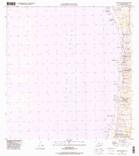
1996 Map of Kauluoa Point
USGS Topo · Published 1998About this map
Honokua Lava Flow of 1950 and other mid-century volcanic events dominate the landscape of the South Kona coast in this late 20th-century survey. The topography illustrates how recent geology reshapes the terrain, with hardened flows cutting through traditional land divisions and reaching the Pacific Ocean at points like Kauluoa Point. Despite the environmental changes, the persistence of local land use is evident in the Haukalua 2 Homesteads and Olelomoana Homesteads, which represent established settlement patterns on the island's western slopes.
Find a feature on this map
50 named features on this map. Tap any name to fly to it.
Don’t see what you’re looking for? This feature index may not catch every label — zoom into the map to look around manually.
Map Details
Editions of this 1996 Kauluoa Point Map
This is the sole edition of this map. No revisions or reprints were ever made.
Other maps of this area

1928 · Hoopuloa
USGS Topo · 1:62,500

1954 · Hawaii South
USGS Topo · 1:250,000

1959 · Hawaii South
USGS Topo · 1:250,000

1959 · Honaunau
USGS Topo · 1:24,000
1960 · Kaunene
USGS Topo · 1:24,000

1961 · Hawaii South
USGS Topo · 1:250,000

1962 · Hawaii South
USGS Topo · 1:250,000

1962 · Milolii
USGS Topo · 1:24,000

1962 · Papa
USGS Topo · 1:24,000
1962 · Kauluoa Point
USGS Topo · 1:24,000