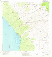
1956 Map of Kawaihae
USGS Topo · Published 1973About this map
Kawaihae serves as the central hub of this mid-century coastal survey, situated where the arid slopes of the Kohala mountains meet the Pacific Ocean. This landscape is defined by its deep cultural history, most notably the Puukohola Heiau overlooking Kawaihae Bay. The map documents the area during a period of transition, showing the Coast Guard Reservation and the Kawaihae Light guiding maritime traffic near the extensive Coral Reef. Inland, the terrain is deeply incised by numerous gulches such as Honokoa Gulch and Waiulaula Gulch, while former habitation areas like Hoepa (Site) and Kawaihae Uka (Site) suggest the shifting settlement patterns of the Big Island. From the recreation areas at Spencer Park and Waikui Beach to the protected upland of the Kohala Forest Reserve, the sheet provides a meticulous view of Hawaii's western shoreline and its complex network of seasonal streams.
Find a feature on this map
73 named features on this map. Tap any name to fly to it.
Don’t see what you’re looking for? This feature index may not catch every label — zoom into the map to look around manually.
Map Details
Editions of this 1956 Kawaihae Map
2 editions found
Other maps of this area

1913 · Kohala
USGS Topo · 1:62,500

1916 · Kohala
USGS Topo · 1:62,500

1916 · Waipio
USGS Topo · 1:62,500

1928 · Puako
USGS Topo · 1:62,500

1954 · Hawaii North
USGS Topo · 1:250,000

1956 · Puu Hinai
USGS Topo · 1:24,000

1956 · Kamuela
USGS Topo · 1:24,000

1956 · Nohonaohae
USGS Topo · 1:24,000

1956 · Kawaihae
USGS Topo · 1:24,000
1957 · Keawanui Bay
USGS Topo · 1:24,000