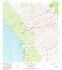
1982 Map of Kawaihae
USGS Topo · Published 1982About this map
The Puukohola Heiau National Historical Site overlooks the Pacific shoreline, marking a significant cultural and architectural landmark in this 1982 survey of the Kohala coast. The map illustrates the coastal interface where steep gulches like Honokoa Gulch and Keawewai Gulch descend from high volcanic cinder cones such as Puu Pili and Puu Ulaula toward Kawaihae Bay. The settlement of Kawaihae serves as a focal point, supported by a Coast Guard Reservation and the Kawaihae Light at the harbor entrance.
Find a feature on this map
59 named features on this map. Tap any name to fly to it.
Don’t see what you’re looking for? This feature index may not catch every label — zoom into the map to look around manually.
Map Details
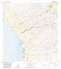
Editions of this 1982 Kawaihae Map
2 editions found
Other maps of this area

1913 · Kohala
USGS Topo · 1:62,500

1916 · Kohala
USGS Topo · 1:62,500

1916 · Waipio
USGS Topo · 1:62,500

1928 · Puako
USGS Topo · 1:62,500

1954 · Hawaii North
USGS Topo · 1:250,000

1956 · Puu Hinai
USGS Topo · 1:24,000

1956 · Kamuela
USGS Topo · 1:24,000

1956 · Nohonaohae
USGS Topo · 1:24,000

1956 · Kawaihae
USGS Topo · 1:24,000
1957 · Keawanui Bay
USGS Topo · 1:24,000