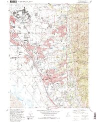
1992 Map of Kaysville
USGS Topo · Published 1992About this map
Hill Air Force Base dominates the northern reaches of this Davis County landscape, where the Wasatch Front meets the suburban expansion of the early 1990s. The map illustrates the close proximity of military infrastructure to the growing residential cores of Clearfield and Layton, connected by the arterial lines of the Union Pacific and Denver and Rio Grande Western railroads. To the east, the terrain rises sharply into the Wasatch National Forest, where steep canyons like Webb Canyon and Bair Canyon channel water toward the valley. Water management is a defining theme, visible in the Davis-Weber Canal and numerous holding basins like Adams Reservoir. Cultural landmarks include the Utah State University Botanical Gardens and Lakeview Cemetery, while the presence of the Davis Applied Technology Center reflects the area's mid-century educational and industrial shift.
Find a feature on this map
76 named features on this map. Tap any name to fly to it.
Don’t see what you’re looking for? This feature index may not catch every label — zoom into the map to look around manually.
Map Details
Editions of this 1992 Kaysville Map
2 editions found
Other maps of this area

1885 · Salt Lake
USGS Topo · 1:250,000

1885 · Tooele Valley
USGS Topo · 1:250,000

1925 · Ft. Douglas
USGS Topo · 1:125,000

1928 · Ft. Douglas
USGS Topo · 1:125,000

1952 · Saltair NE
USGS Topo · 1:24,000

1952 · Farmington
USGS Topo · 1:24,000

1952 · Bountiful Peak
USGS Topo · 1:24,000

1953 · Tooele
USGS Topo · 1:250,000

1954 · Salt Lake City
USGS Topo · 1:250,000

1954 · Ogden
USGS Topo · 1:250,000