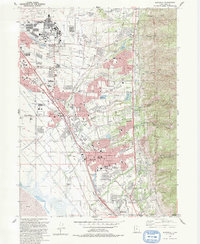
1992 Map of Kaysville
USGS Topo · Published 1992About this map
Hill Air Force Base dominates the northern landscape of this Davis County survey, where military operations meet the rapidly expanding residential centers of Layton and Kaysville. The map illustrates a transitional era of suburban growth, with extensive school networks like Central Junior High Sch and E G King Sch serving the communities established between the mountains and the Great Salt Lake mudflats. Along the eastern edge, the steep rise of the Wasatch National Forest is carved by numerous drainages, including Hobbs Canyon and Adams Canyon. Institutional landmarks are prominent throughout the corridor, notably the Utah State University Agricultural Experiment Sta and the Davis Applied Technology Center. Transportation is anchored by the historic rail connection at Layton Sta, while local landmarks like Lakeview Cemetery and the Oak Ridge Country Club mark the settled community fabric of the early 1990s.
Find a feature on this map
56 named features on this map. Tap any name to fly to it.
Don’t see what you’re looking for? This feature index may not catch every label — zoom into the map to look around manually.
Map Details
Editions of this 1992 Kaysville Map
2 editions found
Other maps of this area

1885 · Salt Lake
USGS Topo · 1:250,000

1885 · Tooele Valley
USGS Topo · 1:250,000

1925 · Ft. Douglas
USGS Topo · 1:125,000

1928 · Ft. Douglas
USGS Topo · 1:125,000

1952 · Saltair NE
USGS Topo · 1:24,000

1952 · Farmington
USGS Topo · 1:24,000

1952 · Bountiful Peak
USGS Topo · 1:24,000

1953 · Tooele
USGS Topo · 1:250,000

1954 · Salt Lake City
USGS Topo · 1:250,000

1954 · Ogden
USGS Topo · 1:250,000