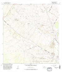
1982 Map of Keamuku
USGS Topo · Published 1985About this map
The Keamuku Lava Flow dominates the landscape of this high-elevation region on the Island of Hawaii, illustrating the powerful volcanic history of the area. This 1982 survey provides a detailed look at the intersection of land use and natural terrain, where the Pohakuloa Training Area (Military Reservation) meets the wilder stretches of the Mauna Loa Forest Reserve. The map traces several volcanic cones, known locally as puu, including Puu Ka Pele and Puu Keekee, which rise above the surrounding Kipuka Puuanahulu. Evidence of the ranching and social history of the district is found at the settlement of Waikii and the Kilohana Girl Scout Camp, while the Saddle Road and Kona Hwy serve as the primary conduits through this remote terrain. The presence of numerous water tanks underscores the logistical challenges of maintaining settlements like Keamuku in an environment defined by porous lava and seasonal gulches like Auwaiakeakua Gulch.
Find a feature on this map
32 named features on this map. Tap any name to fly to it.
Don’t see what you’re looking for? This feature index may not catch every label — zoom into the map to look around manually.
Map Details
Editions of this 1982 Keamuku Map
2 editions found
Other maps of this area

1927 · Kaohe
USGS Topo · 1:62,500

1928 · Puako
USGS Topo · 1:62,500

1928 · Kailua
USGS Topo · 1:62,500

1930 · Kaohe
USGS Topo · 1:62,500

1954 · Hawaii North
USGS Topo · 1:250,000

1956 · Puu Koli
USGS Topo · 1:24,000

1956 · Puu Hinai
USGS Topo · 1:24,000

1956 · Keamuku
USGS Topo · 1:24,000

1956 · Nohonaohae
USGS Topo · 1:24,000

1956 · Makahalau
USGS Topo · 1:24,000