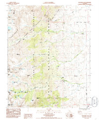
1985 Map of Kearsarge Peak
USGS Topo · Published 1985About this map
Independence Peak and Kearsarge Peak dominate this high-altitude landscape in the eastern Sierra, where the Inyo National Forest meets the boundary of Kings Canyon National Park. The map documents a rugged network of water and trails, featuring the intersection of the John Muir Trail and the California Riding and Hiking Trail. Dozens of alpine lakes, such as Baxter Lakes, Parker Lakes, and Golden Trout Lake, are fed by snowmelt from Mount Mary Austin and Acrodectes Peak. Below the granite ridges, established campsites like Grays Meadow Campground and Oak Creek Campground serve as gateways for travelers entering Onion Valley. The presence of several springs, including Tub Springs and Boron Springs, alongside a Gaging Station on Independence Creek, underscores the critical importance of water management in this high-desert watershed.
Find a feature on this map
47 named features on this map. Tap any name to fly to it.
Don’t see what you’re looking for? This feature index may not catch every label — zoom into the map to look around manually.
Map Details
Editions of this 1985 Kearsarge Peak Map
This is the sole edition of this map. No revisions or reprints were ever made.
Other maps of this area

1907 · Mt. Whitney
USGS Topo · 1:125,000

1919 · Mt. Whitney
USGS Topo · 1:125,000

1937 · Mt. Whitney
USGS Topo · 1:125,000

1948 · Fresno
USGS Topo · 1:250,000

1951 · Independence
USGS Topo · 1:62,500

1953 · Mt. Pinchot
USGS Topo · 1:62,500

1955 · Fresno
USGS Topo · 1:250,000

1956 · Fresno
USGS Topo · 1:250,000

1956 · Mount Whitney
USGS Topo · 1:62,500

1958 · Fresno
USGS Topo · 1:250,000