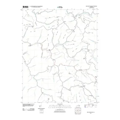
2010 Map of Keen Mountain
USGS Topo · Published 2010About this map
The Levisa Fork cuts a deep path through this Appalachian landscape, anchoring a network of small settlements such as Grimsleyville, Keen Mountain, and Shack Mills. This 2010 survey by the U.S. Geological Survey illustrates the complex topography of Buchanan County, where narrow hollows and steep ridges dictate the placement of roads and homesteads. Landmarks like the Keen Mountain Fire Tower stand on high ground, while historical routes such as Rife's Cemetery Rd and the Maxwell-Bottom Rd wind through the valleys. The map shows the region's traditional reliance on its watercourses and gaps, including Shortt Gap and Coal Gap, for transit and connectivity. Genealogists may find interest in Ward Cemetery and named gaps like Bill Young Gap, reflecting the deep familial roots and the importance of specific ridge crossings in this corner of Virginia.
Find a feature on this map
110 named features on this map. Tap any name to fly to it.
Don’t see what you’re looking for? This feature index may not catch every label — zoom into the map to look around manually.
Map Details
Editions of this 2010 Keen Mountain Map
This is the sole edition of this map. No revisions or reprints were ever made.
Other maps of this area

1886 · Grundy
USGS Topo · 1:125,000

1890 · Grundy
USGS Topo · 1:125,000

1891 · Tazewell
USGS Topo · 1:125,000

1892 · Grundy
USGS Topo · 1:125,000

1895 · Tazewell
USGS Topo · 1:125,000

1897 · Tazewell
USGS Topo · 1:125,000

1910 · Iaeger
USGS Topo · 1:48,000

1912 · Iaeger
USGS Topo · 1:62,500

1914 · Bucu
USGS Topo · 1:48,000

1914 · Iaeger
USGS Topo · 1:48,000