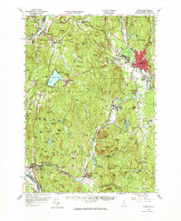
1958 Map of Keene
USGS Topo · Published 1973About this map
The industrial and transportation hub of Keene serves as the focal point of this southwestern New Hampshire landscape, where the Boston and Maine Railroad and Maine Central Railroad intersect. The terrain is defined by the valley of the Ashuelot River, which supported early manufacturing sites such as the Swanzey Factory. To the west, the landscape rises into the ridges of Pisgah Mountain and Mt Pisgah, sheltering a network of upland water bodies including Pisgah Reservoir, Kilburn Pond, and Fullam Pond.
Find a feature on this map
104 named features on this map. Tap any name to fly to it.
Don’t see what you’re looking for? This feature index may not catch every label — zoom into the map to look around manually.
Map Details
Editions of this 1958 Keene Map
3 editions found
Other maps of this area

1887 · Warwick
USGS Topo · 1:62,500

1887 · Winchendon
USGS Topo · 1:62,500

1889 · Warwick
USGS Topo · 1:62,500

1890 · Greenfield
USGS Topo · 1:62,500

1890 · Winchendon
USGS Topo · 1:62,500

1891 · Brattleboro
USGS Topo · 1:62,500

1893 · Brattleboro
USGS Topo · 1:62,500

1894 · Winchendon
USGS Topo · 1:62,500

1894 · Greenfield
USGS Topo · 1:62,500

1894 · Warwick
USGS Topo · 1:62,500