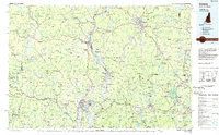
1986 Map of Keene
USGS Topo · Published 1986About this map
The Connecticut River serves as the central artery for this tri-state region during the mid-1980s, dividing the Vermont and New Hampshire borderlands before cutting south into Massachusetts. The landscape is defined by its transition from the steep Green Mountains and peaks like Haystack Mountain in the west to the prominent isolated summit of Monadnock Mountain in the east. This era shows the developed hydro-infrastructure of the valley, notably the Northfield Mountain Pumped Storage Project and the expansive Harriman Reservoir.
Find a feature on this map
216 named features on this map. Tap any name to fly to it.
Don’t see what you’re looking for? This feature index may not catch every label — zoom into the map to look around manually.
Map Details
Editions of this 1986 Keene Map
3 editions found
Other maps of this area

1885 · Northampton
USGS Topo · 1:62,500

1885 · Worcester
USGS Topo · 1:62,500

1886 · Greylock
USGS Topo · 1:62,500

1886 · Hawley
USGS Topo · 1:62,500

1886 · Chesterfield
USGS Topo · 1:62,500

1886 · Worcester
USGS Topo · 1:62,500

1886 · Northampton
USGS Topo · 1:62,500

1886 · Becket
USGS Topo · 1:62,500

1887 · Warwick
USGS Topo · 1:62,500

1887 · Belchertown
USGS Topo · 1:62,500