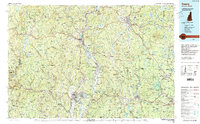
1986 Map of Keene
USGS Topo · Published 1988About this map
The Connecticut River serves as the central geographic spine for this 1980s-era topographical survey, which spans the tri-state borders of New Hampshire, Vermont, and Massachusetts. In this mid-century landscape, major manufacturing centers like Keene, Brattleboro, and Greenfield anchor the region's economy, while the Boston and Maine RR corridors trace the historic industrial development along the river valleys. The map illustrates a period of significant land conservation and water management, visible in the protected expanses of the Green Mountain National Forest and the northern reaches of the Quabbin Reservoir. Local high points like Mount Monadnock and Pisgah Mountain stand as permanent landmarks over a network of state forests and parks. From the winding Mohawk Trail to the hydroelectric reservoirs on the Deerfield River, the map captures the transition between dense New England mill towns and the managed wilderness of the surrounding uplands.
Find a feature on this map
98 named features on this map. Tap any name to fly to it.
Don’t see what you’re looking for? This feature index may not catch every label — zoom into the map to look around manually.
Map Details
Editions of this 1986 Keene Map
3 editions found
Other maps of this area

1885 · Northampton
USGS Topo · 1:62,500

1885 · Worcester
USGS Topo · 1:62,500

1886 · Greylock
USGS Topo · 1:62,500

1886 · Hawley
USGS Topo · 1:62,500

1886 · Chesterfield
USGS Topo · 1:62,500

1886 · Worcester
USGS Topo · 1:62,500

1886 · Northampton
USGS Topo · 1:62,500

1886 · Becket
USGS Topo · 1:62,500

1887 · Warwick
USGS Topo · 1:62,500

1887 · Belchertown
USGS Topo · 1:62,500