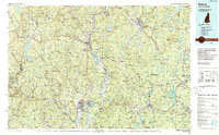
1986 Map of Keene
USGS Topo · Published 1988About this map
The Connecticut River serves as the central artery for this tri-state region in the mid-1980s, where the borders of New Hampshire, Vermont, and Massachusetts converge. Industrial and residential hubs like Keene, Brattleboro, and Greenfield anchor the river valleys, while the surrounding uplands are dominated by protected woodlands and massive water management projects. Large-scale reservoirs such as the Somerset Reservoir, Harriman Reservoir, and a portion of the Quabbin Reservoir underscore the 20th-century transformation of the watershed for regional power and water supply.
Find a feature on this map
307 named features on this map. Tap any name to fly to it.
Don’t see what you’re looking for? This feature index may not catch every label — zoom into the map to look around manually.
Map Details
Editions of this 1986 Keene Map
3 editions found

Other maps of this area

1885 · Northampton
USGS Topo · 1:62,500

1885 · Worcester
USGS Topo · 1:62,500

1886 · Greylock
USGS Topo · 1:62,500

1886 · Hawley
USGS Topo · 1:62,500

1886 · Chesterfield
USGS Topo · 1:62,500

1886 · Worcester
USGS Topo · 1:62,500

1886 · Northampton
USGS Topo · 1:62,500

1886 · Becket
USGS Topo · 1:62,500

1887 · Warwick
USGS Topo · 1:62,500

1887 · Belchertown
USGS Topo · 1:62,500