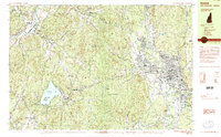
1984 Map of Keene
USGS Topo · Published 1984About this map
The city of Keene serves as the focal point of this 1980s landscape, where urban infrastructure meets the wooded highlands of Cheshire County. To the west, the Connecticut River forms the natural boundary with Vermont, while the Ashuelot River winds through the eastern valley, supporting the growth of North Swanzey. This era shows a community well-integrated with its environment, featuring extensive public lands like Pisgah State Park and Chesterfield Gorge State Park.
Find a feature on this map
54 named features on this map. Tap any name to fly to it.
Don’t see what you’re looking for? This feature index may not catch every label — zoom into the map to look around manually.
Map Details
Editions of this 1984 Keene Map
2 editions found
Other maps of this area

1891 · Brattleboro
USGS Topo · 1:62,500

1893 · Brattleboro
USGS Topo · 1:62,500

1898 · Monadnock
USGS Topo · 1:62,500

1898 · Keene
USGS Topo · 1:62,500

1927 · Bellows Falls
USGS Topo · 1:48,000

1930 · Saxtons River
USGS Topo · 1:48,000

1930 · Lovewell Mountain
USGS Topo · 1:62,500

1930 · Bellows Falls
USGS Topo · 1:62,500

1932 · Brattleboro
USGS Topo · 1:48,000

1932 · Keene
USGS Topo · 1:62,500