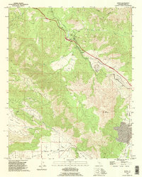
1992 Map of Keene
USGS Topo · Published 1995About this map
Tehachapi Creek carves a path through this mountainous region of Kern County, where the infrastructure of the Southern Pacific railroad defines the local landscape. The map highlights the famous engineering feat known as The Loop near the settlement of Walong, a critical point where the rail line circles back over itself to gain elevation. This 1990s revision captures a series of small trackside communities including Keene, Woodford, and Marcel, many of which were historically vital to the operation of the mountain pass. Beyond the tracks, the terrain transitions into the high basins of Bear Valley and Cummings Valley, showing a mix of agricultural land and isolated Mine or Prospects sites. The presence of the Keene PO and a local Golf Course indicates the evolving nature of these mountain settlements during the late twentieth century.
Find a feature on this map
33 named features on this map. Tap any name to fly to it.
Don’t see what you’re looking for? This feature index may not catch every label — zoom into the map to look around manually.
Map Details
Editions of this 1992 Keene Map
This is the sole edition of this map. No revisions or reprints were ever made.
Other maps of this area

1914 · Caliente
USGS Topo · 1:125,000

1915 · Mojave
USGS Topo · 1:125,000

1929 · Bena
USGS Topo · 1:31,680

1930 · Bear Mountain
USGS Topo · 1:31,680

1932 · Bena
USGS Topo · 1:31,680

1933 · Bear Mountain
USGS Topo · 1:31,680

1943 · Tehachapi
USGS Topo · 1:62,500

1943 · Emerald Mtn
USGS Topo · 1:62,500

1943 · Cummings Mountain
USGS Topo · 1:62,500

1943 · Breckenridge Mountain
USGS Topo · 1:62,500