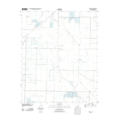
2011 Map of Keevil
USGS Topo · Published 2011About this map
Cypress Creek meanders through this portion of Monroe County, defining a landscape of irrigation and low-lying drainage patterns south of Lake Greenlee. The map centers on the small rail-aligned settlements and agricultural junctions established in the early 20th century. Local family history is well-preserved through a series of namesake burial grounds, including Fitzhugh Cemetery, Finell Cemetery, and Jordan Cemetery. The presence of Mopac Rd tracing an old Missouri Pacific Railroad corridor highlights the historical importance of rail transport in moving timber and crops from this delta region. Scattered hamlets like Keevil, Bayless, and Alfrey are connected by a grid of rural routes such as Chicken Farm Rd and Skinner Rd, illustrating the persistent rural character of the area into the 21st century.
Find a feature on this map
41 named features on this map. Tap any name to fly to it.
Don’t see what you’re looking for? This feature index may not catch every label — zoom into the map to look around manually.
Map Details
Editions of this 2011 Keevil Map
This is the sole edition of this map. No revisions or reprints were ever made.
Other maps of this area

1935 · Clarendon
USGS Topo · 1:62,500

1940 · Holly Grove
USGS Topo · 1:62,500

1940 · Brinkley
USGS Topo · 1:62,500

1941 · De Valls Bluff
USGS Topo · 1:62,500

1941 · Clarendon
USGS Topo · 1:62,500

1948 · Helena
USGS Topo · 1:250,000

1950 · Helena
USGS Topo · 1:250,000

1955 · Helena
USGS Topo · 1:250,000
1957 · Clarendon
USGS Topo · 1:62,500

1957 · Holly Grove
USGS Topo · 1:62,500