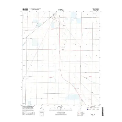
2014 Map of Keevil
USGS Topo · Published 2014About this map
The agricultural landscape of Monroe County, Arkansas, centers on the southern reaches of Brinkley and a series of smaller rural hubs. This 2014 survey details a network of local farm-to-market roads and drainage systems essential to the delta region, including the meandering paths of Cypress Cr and Big Piney Cr. Family and community history is preserved in several small cemeteries scattered across the townships, such as Fitzhugh Cem in the northwest and Saint John Cem further south. The map reflects a quiet rural continuity where established hamlets like Keevil, Emmons, and Alfrey are connected by a grid of named routes like Mopac Rd and Gibbs Rd. These local roads serve the surrounding fields and wetlands, including the Lake Greenlee Reservoir, illustrating the region's managed hydrology and deep-rooted land divisions.
Find a feature on this map
59 named features on this map. Tap any name to fly to it.
Don’t see what you’re looking for? This feature index may not catch every label — zoom into the map to look around manually.
Map Details
Editions of this 2014 Keevil Map
This is the sole edition of this map. No revisions or reprints were ever made.
Other maps of this area

1935 · Clarendon
USGS Topo · 1:62,500

1940 · Holly Grove
USGS Topo · 1:62,500

1940 · Brinkley
USGS Topo · 1:62,500

1941 · De Valls Bluff
USGS Topo · 1:62,500

1941 · Clarendon
USGS Topo · 1:62,500

1948 · Helena
USGS Topo · 1:250,000

1950 · Helena
USGS Topo · 1:250,000

1955 · Helena
USGS Topo · 1:250,000
1957 · Clarendon
USGS Topo · 1:62,500

1957 · Holly Grove
USGS Topo · 1:62,500