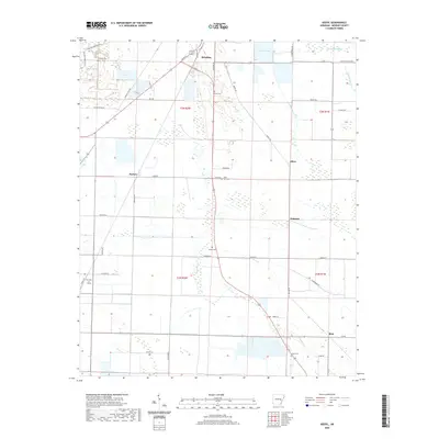
2020 Map of Keevil
USGS Topo · Published 2020About this map
The southern outskirts of Brinkley anchor this survey of Monroe County's agricultural delta. The landscape is defined by the intersection of rural life and natural drainage, where established settlements like Alfrey, Emmons, and Rich are situated alongside the meandering paths of Big Piney Cr and Cypress Cr. The distribution of family and community burial grounds, including Fitzhugh Cem, Finell Cem, and Jordan Cem, suggests a long-standing settlement pattern tied to the local land divisions of the Township of Keevil. Infrastructure such as the Mo Pac Rd and a network of named country routes like Chicken Farm Rd and Swampoddle Rd trace the movement of goods and people across the plains. Large water features like Lake Greenlee and Maple Slough break the gridded agricultural fields, providing central landmarks for the surrounding rural communities.
Find a feature on this map
50 named features on this map. Tap any name to fly to it.
Don’t see what you’re looking for? This feature index may not catch every label — zoom into the map to look around manually.
Map Details
Editions of this 2020 Keevil Map
This is the sole edition of this map. No revisions or reprints were ever made.
Other maps of this area

1935 · Clarendon
USGS Topo · 1:62,500

1940 · Holly Grove
USGS Topo · 1:62,500

1940 · Brinkley
USGS Topo · 1:62,500

1941 · De Valls Bluff
USGS Topo · 1:62,500

1941 · Clarendon
USGS Topo · 1:62,500

1948 · Helena
USGS Topo · 1:250,000

1950 · Helena
USGS Topo · 1:250,000

1955 · Helena
USGS Topo · 1:250,000
1957 · Clarendon
USGS Topo · 1:62,500

1957 · Holly Grove
USGS Topo · 1:62,500