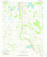
1971 Map of Keevil
USGS Topo · Published 1973About this map
Brinkley serves as the focal point in this portion of Monroe County, where the intersection of the C R I & P and St Louis Southwestern railroads historically shaped the local economy. The landscape is defined by the wetlands of Cypress Creek and Big Piney Creek, which support specialized agriculture as seen in the numerous Minnow Ponds and a large Fish Farm near Lake Greenlee. This survey provides a record of rural life through its network of small communities like Keevil, Alfrey, and Rich. For genealogists, the map is particularly valuable for locating several family and community burial grounds, including Fitzhugh Cem, Jordan Cem, and Upper Cem, alongside rural congregations such as Mt Canaan Ch and New Hope Ch. The presence of the Riddell Landing Strip and a Brinkley Country Club suggests a period of mid-century diversification beyond traditional farming.
Find a feature on this map
30 named features on this map. Tap any name to fly to it.
Don’t see what you’re looking for? This feature index may not catch every label — zoom into the map to look around manually.
Map Details
Editions of this 1971 Keevil Map
This is the sole edition of this map. No revisions or reprints were ever made.
Other maps of this area

1935 · Clarendon
USGS Topo · 1:62,500

1940 · Holly Grove
USGS Topo · 1:62,500

1940 · Brinkley
USGS Topo · 1:62,500

1941 · De Valls Bluff
USGS Topo · 1:62,500

1941 · Clarendon
USGS Topo · 1:62,500

1948 · Helena
USGS Topo · 1:250,000

1950 · Helena
USGS Topo · 1:250,000

1955 · Helena
USGS Topo · 1:250,000
1957 · Clarendon
USGS Topo · 1:62,500

1957 · Holly Grove
USGS Topo · 1:62,500