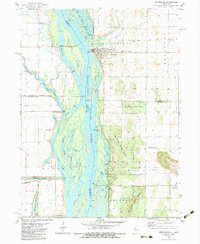
1982 Map of Keithsburg
USGS Topo · Published 1983About this map
Keithsburg sits at the heart of this riverfront survey, positioned where Pope Creek meets the wide expanse of the Mississippi River. The town is flanked by a complex network of backwater channels and islands, including Blackhawk Island and Blackhawk Chute, illustrating the dynamic nature of the river border between Illinois and Iowa. To the north, the Mark Twain National Wildlife Refuge preserves the shoreline, while an Old Railroad Grade cutting through the landscape hints at the area's former transportation corridors.
Find a feature on this map
56 named features on this map. Tap any name to fly to it.
Don’t see what you’re looking for? This feature index may not catch every label — zoom into the map to look around manually.
Map Details
Editions of this 1982 Keithsburg Map
This is the sole edition of this map. No revisions or reprints were ever made.
Other maps of this area

1934 · Oquawka
USGS Topo · 1:48,000

1934 · Burlington
USGS Topo · 1:48,000

1935 · Keithsburg
USGS Topo · 1:48,000

1940 · Oquawka
USGS Topo · 1:62,500

1940 · Burlington
USGS Topo · 1:62,500

1941 · Keithsburg
USGS Topo · 1:62,500

1946 · Wapello
USGS Topo · 1:62,500

1949 · Wapello
USGS Topo · 1:62,500

1953 · Toolesboro
USGS Topo · 1:24,000
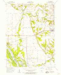
1953 · Joy
USGS Topo · 1:24,000