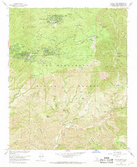
1967 Map of Keller Peak
USGS Topo · Published 1968About this map
Green Valley Lake and Running Springs serve as the primary mountain settlements in this high-elevation portion of the San Bernardino National Forest. In the late 1960s, the area was a concentrated hub for youth recreation and organizational retreats, evidenced by numerous sites like the Hollywood Boys Club, Camp Awahanee, and Camp Wintaka nestled among the peaks. The landscape is defined by its dramatic relief, rising toward Keller Peak and Mill Peak, with the Rim of the World Drive providing the central transportation spine through the communities.
Find a feature on this map
82 named features on this map. Tap any name to fly to it.
Don’t see what you’re looking for? This feature index may not catch every label — zoom into the map to look around manually.
Map Details
Editions of this 1967 Keller Peak Map
3 editions found
Other maps of this area

1899 · Redlands
USGS Topo · 1:62,500

1901 · Southern California Sheet No. 1
USGS Topo · 1:250,000

1901 · Redlands
USGS Topo · 1:62,500

1902 · Deep Creek
USGS Topo · 1:62,500

1902 · San Gorgonio
USGS Topo · 1:125,000

1904 · Southern California Sheet No. 1
USGS Topo · 1:250,000

1947 · Lucerne Valley
USGS Topo · 1:62,500

1949 · Lucerne Valley
USGS Topo · 1:62,500

1953 · San Bernardino
USGS Topo · 1:250,000
1953 · Harrison Mtn.
USGS Topo · 1:24,000