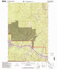
1996 Map of Kellogg East
USGS Topo · Published 1999About this map
The South Fork Coeur d'Alene River valley serves as the industrial and social spine of this Shoshone County landscape in the mid-1990s. Heavy extraction history is evident in the dense concentration of mining sites, including the Alhambra Mine, Crescent Mine, and Polaris Mine, which define the rugged northern edge of the Coeur d'Alene National Forest. A poignant local landmark, the Sunshine Mine Disaster Memorial, stands near the river, anchoring the area's identity to its silver mining heritage.
Find a feature on this map
63 named features on this map. Tap any name to fly to it.
Don’t see what you’re looking for? This feature index may not catch every label — zoom into the map to look around manually.
Map Details
Editions of this 1996 Kellogg East Map
This is the sole edition of this map. No revisions or reprints were ever made.
Other maps of this area

1901 · Coeur D'Alene District
USGS Topo · 1:62,500

1903 · Coeur D'Alene District
USGS Topo · 1:62,500

1906 · Coeur D'Alene District
USGS Topo · 1:62,500

1909 · Cataldo
USGS Topo · 1:125,000

1911 · Cataldo
USGS Topo · 1:125,000

1914 · Avery
USGS Topo · 1:125,000

1917 · Avery
USGS Topo · 1:125,000

1932 · Trout Creek
USGS Topo · 1:125,000

1935 · Trout Creek
USGS Topo · 1:125,000

1936 · Trout Creek
USGS Topo · 1:125,000