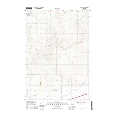
2014 Map of Kelly Hills
USGS Topo · Published 2014About this map
Kelly Hills rises north of the Yellowstone River in this rural landscape spanning the Park and Sweet Grass county line. The terrain is defined by a dense network of drainages, including the W Fork Duck Creek and E Fork Duck Creek, which carve through the high ground. At the northern edge of the map, Sioux Crossing marks a point along the water, while the southern corridor reflects historic transit routes. The presence of Old Stage Rd and Yellowstone Trail Rd south of the river indicates the area's legacy as a regional passage. Further inland, the landscape is sparsely developed, consisting primarily of section-line divisions and remote roads like Duck Creek Rd and Norht River Rd that follow the natural contours of the creeks and hills.
Find a feature on this map
30 named features on this map. Tap any name to fly to it.
Don’t see what you’re looking for? This feature index may not catch every label — zoom into the map to look around manually.
Map Details
Editions of this 2014 Kelly Hills Map
This is the sole edition of this map. No revisions or reprints were ever made.
Other maps of this area

1891 · Livingston
USGS Topo · 1:250,000

1893 · Livingston
USGS Topo · 1:250,000

1947 · Bozeman
USGS Topo · 1:250,000

1948 · Bozeman
USGS Topo · 1:250,000
1951 · Grosfield Ranch
USGS Topo · 1:24,000
1951 · Raspberry Butte
USGS Topo · 1:24,000

1951 · Kelly Hills
USGS Topo · 1:24,000

1951 · Springdale
USGS Topo · 1:24,000

1951 · Hunters Hot Springs
USGS Topo · 1:24,000

1951 · Elton
USGS Topo · 1:24,000