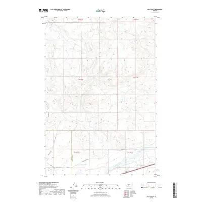
2020 Map of Kelly Hills
USGS Topo · Published 2020About this map
The Yellowstone River cuts through the southern portion of this landscape, serving as the primary geographic anchor for the surrounding valley and its agricultural infrastructure. In this 2020 record of Sweet Grass and Park counties, the complex water management systems of the era are clearly visible, including the Hunters Hot Springs Canal and the Prather Mayborn Westfall Ditch. These irrigation features support the ranching and farming operations that define the river basin below the prominent Kelly Hills. North of the river, the terrain is defined by a series of drainages such as W Fork Duck Cr and E Fork Duck Cr, while the historic transportation corridor is traced by the N Yellowstone Trail Rd and Convict Grade Rd. The map illustrates the transition from the high, dissected hills down to the fertile, managed riparian zone along the Yellowstone.
Find a feature on this map
31 named features on this map. Tap any name to fly to it.
Don’t see what you’re looking for? This feature index may not catch every label — zoom into the map to look around manually.
Map Details
Editions of this 2020 Kelly Hills Map
This is the sole edition of this map. No revisions or reprints were ever made.
Other maps of this area

1891 · Livingston
USGS Topo · 1:250,000

1893 · Livingston
USGS Topo · 1:250,000

1947 · Bozeman
USGS Topo · 1:250,000

1948 · Bozeman
USGS Topo · 1:250,000
1951 · Grosfield Ranch
USGS Topo · 1:24,000
1951 · Raspberry Butte
USGS Topo · 1:24,000

1951 · Kelly Hills
USGS Topo · 1:24,000

1951 · Springdale
USGS Topo · 1:24,000

1951 · Hunters Hot Springs
USGS Topo · 1:24,000

1951 · Elton
USGS Topo · 1:24,000