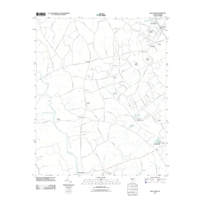
2011 Map of Kellytown
USGS Topo · Published 2011About this map
Kellytown and the surrounding agricultural lands of Darlington County are defined by a complex network of wetlands and small settlements at the start of the 2010s. The landscape is characterized by its numerous water features, including the Lynches River which snakes along the western edge, and several distinctive "bays" or depressions like Big Cypress Bay and Little Cypress Bay. The area shows a transition from historical crossroads like Ashland and Stokes Bridge to residential developments such as Forest Hills and Botany Woods near the northeastern corner. Local history is anchored by numerous family and community burial grounds, including the Grantham Cemetery and Bethlehem Cemetery, while the presence of Segars Millpond and Marco Millpond points to the long-standing role of water management and milling in the region's economy.
Find a feature on this map
111 named features on this map. Tap any name to fly to it.
Don’t see what you’re looking for? This feature index may not catch every label — zoom into the map to look around manually.
Map Details
Editions of this 2011 Kellytown Map
This is the sole edition of this map. No revisions or reprints were ever made.
Other maps of this area

1941 · Spartanburg
USGS Topo · 1:250,000

1953 · Spartanburg
USGS Topo · 1:250,000

1957 · Ashwood
USGS Topo · 1:62,500

1960 · Spartanburg
USGS Topo · 1:250,000

1963 · Spartanburg
USGS Topo · 1:250,000

1964 · Spartanburg
USGS Topo · 1:250,000
1968 · Hartsville North
USGS Topo · 1:24,000
1968 · Lake Robinson
USGS Topo · 1:24,000

1968 · Kellytown
USGS Topo · 1:24,000
1968 · Hartsville South
USGS Topo · 1:24,000