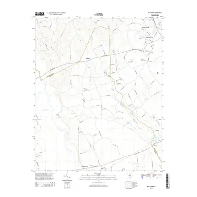
2014 Map of Kellytown
USGS Topo · Published 2014About this map
Sparrow Swamp and Lynches River define the watery landscape of this Darlington and Lee County border region. In the western reaches of Hartsville, the transition from the municipal center to rural communities is marked by a high concentration of family and community burial grounds, such as Kellytown Cem, Liberty Hill Cem, and Bethlehem Cem. The map documents the persistent agricultural and swamp-basin character of areas like Ashland and Alcot, where numerous small runs and bays weave between road networks like Kelleybridge Rd.
Find a feature on this map
121 named features on this map. Tap any name to fly to it.
Don’t see what you’re looking for? This feature index may not catch every label — zoom into the map to look around manually.
Map Details
Editions of this 2014 Kellytown Map
This is the sole edition of this map. No revisions or reprints were ever made.
Other maps of this area

1941 · Spartanburg
USGS Topo · 1:250,000

1953 · Spartanburg
USGS Topo · 1:250,000

1957 · Ashwood
USGS Topo · 1:62,500

1960 · Spartanburg
USGS Topo · 1:250,000

1963 · Spartanburg
USGS Topo · 1:250,000

1964 · Spartanburg
USGS Topo · 1:250,000
1968 · Hartsville North
USGS Topo · 1:24,000
1968 · Lake Robinson
USGS Topo · 1:24,000

1968 · Kellytown
USGS Topo · 1:24,000
1968 · Hartsville South
USGS Topo · 1:24,000