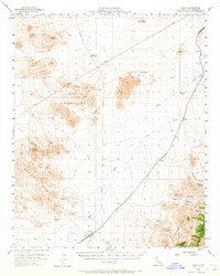
1955 Map of Kelso
USGS Topo · Published 1965About this map
Kelso and the Union railroad corridor anchor this high-desert landscape in the mid-1950s, serving as a vital nexus for transportation and resource extraction. The map reveals a network of industrial sites, including numerous unnamed Shafts and Prospects scattered near the Providence MTS and Kelso Peak. Historical movement through the region is evidenced by the Old Government Road, which cuts across the terrain past Marl Spring, a critical water source in an arid environment otherwise defined by ephemeral drainage like Willow Wash. Along the rail line, small settlements such as Cima, Elora, and Dawes mark the progress of the steam and diesel era. High elevations are punctuated by volcanic features like Lava beds and Wildcat Butte, contrasting with the lower basins where Rainbow Wells and Eightmile Tank provided the essential water infrastructure required for both mining operations and steam locomotives.
Find a feature on this map
27 named features on this map. Tap any name to fly to it.
Don’t see what you’re looking for? This feature index may not catch every label — zoom into the map to look around manually.
Map Details
Editions of this 1955 Kelso Map
3 editions found

Other maps of this area

1910 · Ivanpah
USGS Topo · 1:250,000

1912 · Ivanpah
USGS Topo · 1:250,000

1942 · Ivanpah
USGS Topo · 1:250,000

1942 · Amboy
USGS Topo · 1:250,000

1943 · Amboy
USGS Topo · 1:250,000

1947 · Kingman
USGS Topo · 1:250,000

1948 · Kingman
USGS Topo · 1:250,000

1954 · Needles
USGS Topo · 1:250,000

1954 · Kingman
USGS Topo · 1:250,000

1955 · Kingman
USGS Topo · 1:250,000