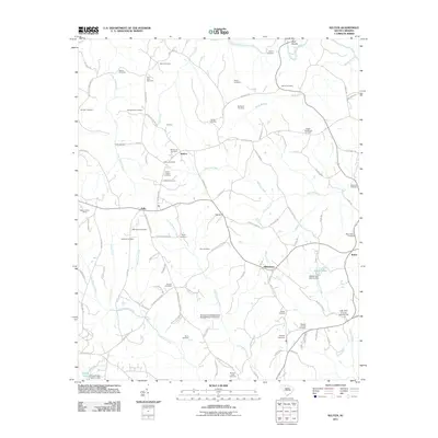
2011 Map of Kelton
USGS Topo · Published 2011About this map
The Pacolet River flows across the northern reach of this South Carolina landscape, defining a rural region deeply rooted in family history. Dozens of family-named burial grounds and churches are scattered throughout the countryside, including the Mount Joy Cemetery and Hames-Gault Cemetery, providing a dense record of the area's genealogical fabric. Small communities like Kelton, Kelly, and Adamsburg serve as local hubs connected by a network of winding roads such as the Pea Ridge Hwy. The terrain is marked by notable features like Bald Rock and several modern water management structures, including the Adams Lake Dam, which highlights the mid-century development of the local watershed. At Kelly Lookout Tower, the map captures a high point overlooking a landscape of creek systems like Peter Hawk Creek and Big Browns Creek that drain into the Pacolet.
Find a feature on this map
111 named features on this map. Tap any name to fly to it.
Don’t see what you’re looking for? This feature index may not catch every label — zoom into the map to look around manually.
Map Details
Editions of this 2011 Kelton Map
This is the sole edition of this map. No revisions or reprints were ever made.
Other maps of this area

1907 · Sharon
USGS Topo · 1:62,500

1941 · Spartanburg
USGS Topo · 1:250,000

1953 · Spartanburg
USGS Topo · 1:250,000

1960 · Spartanburg
USGS Topo · 1:250,000

1963 · Spartanburg
USGS Topo · 1:250,000

1964 · Spartanburg
USGS Topo · 1:250,000
1968 · Wilkinsville
USGS Topo · 1:24,000
1969 · Pacolet Mills
USGS Topo · 1:24,000

1969 · Union West
USGS Topo · 1:24,000

1969 · Kelton
USGS Topo · 1:24,000