1999 Map of Kempshall Mtn
USGS Topo · Published 2001About this map
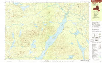
The Adirondack Park interior near the borders of Hamilton, Franklin, and Essex Counties is defined by the prominent ribbon of Long Lake and the winding Raquette River. This late-twentieth-century landscape showcases a mix of recreational and remote landmarks, including the Northville Placid Trail as it traverses the eastern shore. Localized activity is marked by the Boy Scout Camp on the shores of Mcrorie Lake and the Island House situated within the main lake.
Find a feature on this map
65 named features on this map. Tap any name to fly to it.
Don’t see what you’re looking for? This feature index may not catch every label — zoom into the map to look around manually.
Map Details
Editions of this 1999 Kempshall Mtn Map
This is the sole edition of this map. No revisions or reprints were ever made.
Other maps of this area

1898 · Newcomb
USGS Topo · 1:62,500

1901 · Newcomb
USGS Topo · 1:62,500

1903 · Raquette Lake
USGS Topo · 1:62,500

1903 · Blue Mountain
USGS Topo · 1:62,500

1904 · Santanoni
USGS Topo · 1:62,500

1904 · Long Lake
USGS Topo · 1:62,500

1907 · Tupper Lake
USGS Topo · 1:62,500

1948 · Ogdensburg
USGS Topo · 1:250,000

1950 · Utica
USGS Topo · 1:250,000

1951 · Ogdensburg
USGS Topo · 1:250,000