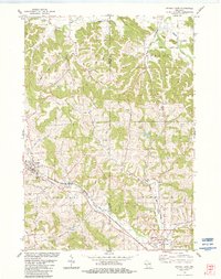
1983 Map of Kendall East
USGS Topo · Published 1984About this map
Elroy-Sparta State Trail follows a corridor between Kendall and Elroy in this 1980s-era study of the Monroe and Juneau County border. This stretch of the Chicago and North Western railroad line reveals a landscape shaped by narrow valleys and significant ridges, such as Clifton Ridge. The map identifies several small community hubs and cemeteries, including Fountain City Cem and West Lemonweir Cem, which are vital for genealogical research in this part of Wisconsin. The complex drainage of the Baraboo River and Little Lemonweir River indicates the varying topography that dictated local settlement patterns. Distinctive rural landmarks like the Townhall near Cleaver Creek and several quarries highlight the local government and extraction industry that sustained these townships during the late 20th century.
Find a feature on this map
32 named features on this map. Tap any name to fly to it.
Don’t see what you’re looking for? This feature index may not catch every label — zoom into the map to look around manually.
Map Details
Editions of this 1983 Kendall East Map
This is the sole edition of this map. No revisions or reprints were ever made.
Other maps of this area

1919 · Kendall
USGS Topo · 1:62,500

1921 · Mauston
USGS Topo · 1:62,500

1921 · Kendall
USGS Topo · 1:62,500

1927 · Hillsboro
USGS Topo · 1:62,500

1956 · Reedsburg
USGS Topo · 1:62,500

1958 · La Crosse
USGS Topo · 1:250,000

1961 · La Crosse
USGS Topo · 1:250,000

1962 · Kendall
USGS Topo · 1:62,500

1962 · Mauston
USGS Topo · 1:62,500

1965 · La Crosse
USGS Topo · 1:250,000