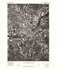
1976 Map of Sparta NE
USGS Topo · Published 1978About this map
Sparta serves as the central hub of this Monroe County orthophotoquad, where the rigid grid of the city meets the meandering course of the La Crosse River. Based on aerial imagery from May 1976, the map reveals a landscape defined by sharp contrasts between urban development and the surrounding dairy country. The expansion of highways is evident, cutting through the farmland south and east of the city center. To the north, the small settlement of Angelo sits near the confluence of local waterways, including Silver Creek. Further south, the rural community of Leon anchors the lower portion of the sheet. This photographic survey provides a rare look at mid-1970s land use, capturing the precise layout of individual farmsteads and the emerging infrastructure of the Interstate era.
Find a feature on this map
5 named features on this map. Tap any name to fly to it.
Don’t see what you’re looking for? This feature index may not catch every label — zoom into the map to look around manually.
Map Details
Editions of this 1976 Sparta NE Map
This is the sole edition of this map. No revisions or reprints were ever made.
Other maps of this area

1909 · Sparta
USGS Topo · 1:62,500

1916 · Tomah
USGS Topo · 1:62,500

1928 · Melrose
USGS Topo · 1:48,000

1947 · Millston
USGS Topo · 1:62,500

1947 · Sparta
USGS Topo · 1:62,500

1949 · Millston
USGS Topo · 1:62,500

1949 · Sparta
USGS Topo · 1:62,500

1949 · Tomah
USGS Topo · 1:62,500

1949 · Melrose
USGS Topo · 1:62,500

1953 · Eau Claire
USGS Topo · 1:250,000