1949 Map of Melrose
USGS Topo · Published 1949About this map
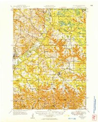
The Black River carves a winding path through this corner of Wisconsin, anchoring a landscape defined by its numerous coulees and narrow valleys. This late 1940s survey reveals a dense network of rural infrastructure, where small community hubs like Melrose and Cataract are supported by an exceptional number of one-room schoolhouses, including Stark Valley Sch and Jenkins Valley Sch. The presence of churches such as Little Norway Ch and St Columbkille Ch reflects the early ethnic settlement patterns of Jackson and Monroe Counties.
Find a feature on this map
81 named features on this map. Tap any name to fly to it.
Don’t see what you’re looking for? This feature index may not catch every label — zoom into the map to look around manually.
Map Details
Editions of this 1949 Melrose Map
This is the sole edition of this map. No revisions or reprints were ever made.
Other maps of this area

1909 · Sparta
USGS Topo · 1:62,500

1916 · Tomah
USGS Topo · 1:62,500

1924 · Black River Falls
USGS Topo · 1:62,500

1926 · Black River Falls
USGS Topo · 1:62,500

1926 · North Bend
USGS Topo · 1:62,500

1927 · Blair
USGS Topo · 1:62,500

1927 · La Crosse
USGS Topo · 1:62,500

1928 · Melrose
USGS Topo · 1:48,000

1929 · North Bend
USGS Topo · 1:62,500

1930 · La Crosse
USGS Topo · 1:62,500