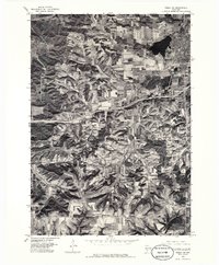
1976 Map of Tomah NE
USGS Topo · Published 1986About this map
Tomah serves as the primary hub in this Monroe County orthophotograph, where the urban grid meets the agricultural landscape of central Wisconsin. The imagery reveals the complex relationship between the built environment and the natural drainage patterns that flow toward the reservoir labeled Tomah. Further south, the rural settlement of Ridgeville stands amidst a patchwork of contoured farm fields, illustrating the era's land-use practices. Unlike a traditional topographic map, this aerial survey provides a direct view of the mid-1970s vegetation cover and road network, including the path of Interstate 90 as it cuts across the township. The visual contrast between the concentrated development in the northeast and the dispersed farmsteads to the south highlights the region's shift from a dense railroad-influenced town center to a modern highway-connected landscape.
Find a feature on this map
6 named features on this map. Tap any name to fly to it.
Don’t see what you’re looking for? This feature index may not catch every label — zoom into the map to look around manually.
Map Details
Editions of this 1976 Tomah NE Map
2 editions found
Other maps of this area

1916 · Tomah
USGS Topo · 1:62,500

1919 · Kendall
USGS Topo · 1:62,500

1921 · Kendall
USGS Topo · 1:62,500

1947 · Millston
USGS Topo · 1:62,500

1949 · Millston
USGS Topo · 1:62,500

1949 · Tomah
USGS Topo · 1:62,500

1953 · Eau Claire
USGS Topo · 1:250,000

1958 · Eau Claire
USGS Topo · 1:250,000

1958 · Wyeville
USGS Topo · 1:48,000

1958 · La Crosse
USGS Topo · 1:250,000