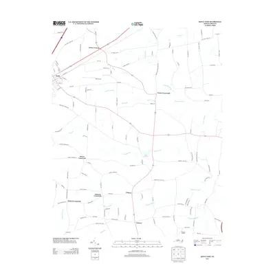
2013 Map of Kenly East
USGS Topo · Published 2013About this map
Kenly and its surrounding rural hamlets are defined by a network of historic intersections and slow-moving drainages in this coastal plain landscape. The area is characterized by several distinctive crossroads communities including Kirbys Crossing, Watson Crossroads, and Hickory Crossroads, which served as local gathering points for the farming population. Low-lying wetlands and branches dictate the local geography, with Nelson Swamp, Juniper Swamp, and Nahunta Swamp threading between the dispersed settlements. The presence of both Kenly Airport and Benton's Airfield highlights the importance of small-scale aviation in this part of Johnston County. To the south, the Sässer Millpond along the Great Swamp indicates the historical utilization of the region's hydraulic resources. This survey captures a transition in the late twentieth and early twenty-first centuries where traditional agricultural communities like Pinkney and Nahunta remained resilient as modern infrastructure like Ramblewood Pl and Saint Marys Church Rd expanded.
Find a feature on this map
115 named features on this map. Tap any name to fly to it.
Don’t see what you’re looking for? This feature index may not catch every label — zoom into the map to look around manually.
Map Details
Editions of this 2013 Kenly East Map
This is the sole edition of this map. No revisions or reprints were ever made.
Other maps of this area

1902 · Kenly
USGS Topo · 1:62,500

1903 · Kenly
USGS Topo · 1:62,500

1904 · Wilson
USGS Topo · 1:62,500

1953 · Rocky Mount
USGS Topo · 1:250,000

1953 · Raleigh
USGS Topo · 1:250,000

1954 · Rocky Mount
USGS Topo · 1:250,000

1954 · Raleigh
USGS Topo · 1:250,000

1957 · Goldsboro
USGS Topo · 1:62,500

1974 · Northwest Goldsboro
USGS Topo · 1:24,000
1974 · Princeton
USGS Topo · 1:24,000