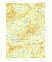
1936 Map of Kennebago Lake
USGS Topo · Published 1936About this map
Kennebago Lake and the surrounding wilderness of Franklin County appear here during the mid-1930s, showing a landscape defined by logging camps and remote outpost settlements. The industrial footprint of the era is evident at Langtown Mill and several numbered outposts such as Camp No 10 and Camp No 11, while the presence of Kennebago Sch, Langtown Sch, and Dallas Sch indicates established rural communities in these townships. The historic Arnold Trail skirts the northern edge of the map, following a path through Alder Stream. This survey, compiled in part from aerial photographs taken by the U.S. Army Air Corps, provides a clear view of the complex hydrology of the region, from the primary waters of Loon Lake and Tim Pond to specialized features like Skedaddle Cove and Lost Logan.
Find a feature on this map
74 named features on this map. Tap any name to fly to it.
Don’t see what you’re looking for? This feature index may not catch every label — zoom into the map to look around manually.
Map Details
Editions of this 1936 Kennebago Lake Map
3 editions found

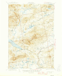
Other maps of this area

1928 · Chain Lakes
USGS Topo · 1:48,000

1928 · Spencer
USGS Topo · 1:48,000

1928 · Stratton
USGS Topo · 1:48,000

1929 · Phillips
USGS Topo · 1:48,000

1931 · Cupsuptic
USGS Topo · 1:48,000

1932 · Phillips
USGS Topo · 1:62,500

1932 · Stratton
USGS Topo · 1:62,500

1932 · Kennebago Lake
USGS Topo · 1:48,000

1932 · Spencer
USGS Topo · 1:62,500

1932 · Arnold Pond
USGS Topo · 1:48,000