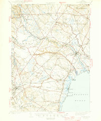
1944 Map of Kennebunk
USGS Topo · Published 1944About this map
The Mousam River and Kennebunk River dictate the development of this coastal York County landscape, where the inland mills of Alfred Mills and Roberts Mills once powered the local economy. In the early 1940s, the region was defined by a network of rural school districts, including School No 14 and School No 7, alongside small crossroads like Highpine and Wells Branch. The coastal strip shows the established seasonal character of Wells Beach and Ogunquit Beach, while the interior remains dominated by significant wetlands such as The Great Heath and Johns Swamp. Industrial and transportation infrastructure is prominent, from the Sanford Airport to the vital corridor of the Boston and Maine Railroad. Local landmarks like the State Police Sta near Elms and the North Chapel provide specific points of reference for genealogists tracing family locations in the mid-20th century.
Find a feature on this map
95 named features on this map. Tap any name to fly to it.
Don’t see what you’re looking for? This feature index may not catch every label — zoom into the map to look around manually.
Map Details
Editions of this 1944 Kennebunk Map
2 editions found
Other maps of this area

1891 · Portland
USGS Topo · 1:62,500

1891 · Biddeford
USGS Topo · 1:62,500

1891 · Berwick
USGS Topo · 1:62,500

1891 · Kennebunk
USGS Topo · 1:62,500

1891 · Buxton
USGS Topo · 1:62,500

1891 · Newfield
USGS Topo · 1:62,500

1892 · Buxton
USGS Topo · 1:62,500

1893 · Kennebunk
USGS Topo · 1:62,500

1893 · Dover
USGS Topo · 1:62,500

1893 · Berwick
USGS Topo · 1:62,500