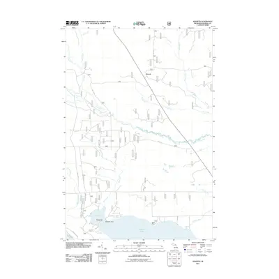
2011 Map of Kenneth
USGS Topo · Published 2011About this map
Kenneth stands as a primary settlement point in this Mackinac County interior, where the land is defined by an intricate network of waterways draining toward the Great Lakes. The Carp River and its South Branch wind through the central terrain, eventually joined by numerous tributaries like Bissel Creek and Silver Creek. To the south, the landscape opens into the substantial waters of Brevort Lake, featuring distinct landmarks such as Black Point and Schaeffer Point. This 2011 survey illustrates a region largely characterized by its natural hydrology and recreational access, notably at the Brevort Lake Campground near Boedne Bay. The presence of established local routes like Town Line Rd, Borland Rd, and Schaeffer Rd provides a clear view of how rural access and land divisions have been maintained in this portion of the Upper Peninsula, terminating at the northern edge of Lake Michigan.
Find a feature on this map
25 named features on this map. Tap any name to fly to it.
Don’t see what you’re looking for? This feature index may not catch every label — zoom into the map to look around manually.
Map Details
Editions of this 2011 Kenneth Map
This is the sole edition of this map. No revisions or reprints were ever made.
Other maps of this area

1931 · Epoufette SE
USGS Topo · 1:31,680

1931 · Epoufette NE
USGS Topo · 1:31,680

1931 · Moran NE
USGS Topo · 1:31,680

1931 · Ozark SE
USGS Topo · 1:31,680

1948 · Moran NE
USGS Topo · 1:31,680

1948 · Moran NW
USGS Topo · 1:31,680

1954 · Sault Sainte Marie
USGS Topo · 1:250,000

1955 · Cheboygan
USGS Topo · 1:250,000

1956 · Sault Sainte Marie
USGS Topo · 1:250,000

1957 · Sault Sainte Marie
USGS Topo · 1:250,000