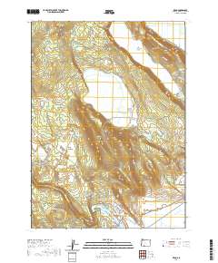
2020 Map of Keno
USGS Topo · Published 2020About this map
Keno sits at the southwestern edge of this landscape, positioned along the controlled waters of the Klamath River and the Keno Reservoir. The map reveals a transition from the lower river valley near the Keno Bridge to the complex high-country drainage systems of the southern Cascades. The timber industry's footprint is evident through the extensive reach of the Weyerhaeuser Timber Company Rd, which snakes through the southeastern terrain. To the north and west, the landscape is defined by natural catchments and managed water features, including the Wocus Drainage Canal feeding into Wocus Marsh and the isolated waters of Round Lake and Oatman Lake. Significant elevation markers such as Indian Spring Ridge and Round Lake Hill overlook a network of seasonal springs and naming-specific flats like Indian Spring Flat, offering a detailed view of how this rugged Oregon terrain was mapped for modern land management.
Find a feature on this map
50 named features on this map. Tap any name to fly to it.
Don’t see what you’re looking for? This feature index may not catch every label — zoom into the map to look around manually.
Map Details
Editions of this 2020 Keno Map
This is the sole edition of this map. No revisions or reprints were ever made.
Other maps of this area

1889 · Klamath
USGS Topo · 1:250,000

1891 · Ashland
USGS Topo · 1:250,000

1893 · Ashland
USGS Topo · 1:250,000

1894 · Klamath
USGS Topo · 1:250,000

1897 · Ashland
USGS Topo · 1:250,000

1955 · Lake O' Woods
USGS Topo · 1:62,500

1955 · Surveyor Mtn
USGS Topo · 1:62,500

1955 · Klamath Falls
USGS Topo · 1:250,000

1955 · Medford
USGS Topo · 1:250,000

1957 · Medford
USGS Topo · 1:250,000